Irina Merzliakova,
Ph. D. Institute of Geography, Russian Academy of Sciences, Moscow
E-mail:
imerz@history.ihst.ru
Alexei Karimov,
Ph.D., Institute for the History of Science and Technology, Russian Academy of Sciences, Moscow
E-mail:
krm@history.ihst.ru
The history of administrative division now is not only the matter of pure academic interest but is of some practical means. A wide spectrum of data on nature, land use, population, economy, culture and social life was gathered, processed and stored by the government with the affiliation to the existing administrative division.
The demand for such data comes now out of a broad scientific community [1] : historians, political scientists, geographers, economists, ecologists, geologists, linguists. Historians apply more and more spatial analysis, and geographers - historical methods. Rapidly developing information technology makes it easier to integrate both. There were few attempts in Russia to integrate spatially referenced historical data. The main obstacles for that were:
Some specialists compiled datasets that included history of administrative division for their narrow purposes. The dataset from old herbarium records with administrative affiliation of more then 2000 plant findings was built for the study of tree-plant refuges under last glaciation. It helped to convert old placenames and administrative affiliation of findings into the modern one (Kozharinov, 1995).
Some 25-20 years ago history of administrative division was studied within a project [2] of the Atlas of the History of the USSR with partial success. A lot of map sources had been revealed (Kabuzan, 1981), but the project team had been unable to overcome the problems mentioned above. Currently professor A.V. Postnikov from the Institute for the History of Science in Moscow wrote a very detailed book on the history of delimitation of the Southern boundary of the Russian Empire at Pamir (Postnikov 1998, 2001) and now is working on a book on the history of the Russian boundaries in Central Asia. Dr. N.N. Kamedchikov and late professor A.A. Lutyi from the Institute of Geography in Moscow worked on digitization of Soviet administrative division for population census of 1959 and 1989. There is information on GIS of Belorussian historical boundaries project (Karchevskii K.A., 2000). Institute of History of Russia published a map of Russian administrative division of XVII century [3] (Administrative division..., 1996).
The purpose of our project is to build historical GIS of the Russian administrative division and its changes for the late XVIII - early XX centuries. This will provide a flexible framework to organize and compare spatially referenced historical data for scholarly and academic community.
It is now good time to reveal, study and expose Russian archive maps and historical data. Even ten years ago the Russian old maps were hardly available for researchers. Almost all of the archival maps despite of their age and scale were classified. This was an obstacle for research in various fields and badly influenced at the comparative study of the Russian history, geography and cartography in the international context. The reforms of the last ten years opened the archives and cartographic collections for research, and we hope things will not go back.
The administrative division and boundaries should be closely related to the political power of the country, it's views on itself, it's subjects, aims and functions. Making "good fences" is exactly how the state "is seeing" (Scott, 1998) the country and the people, a discourse of power and governance. In Russia there could be identified four main stages in the history of administrative division.
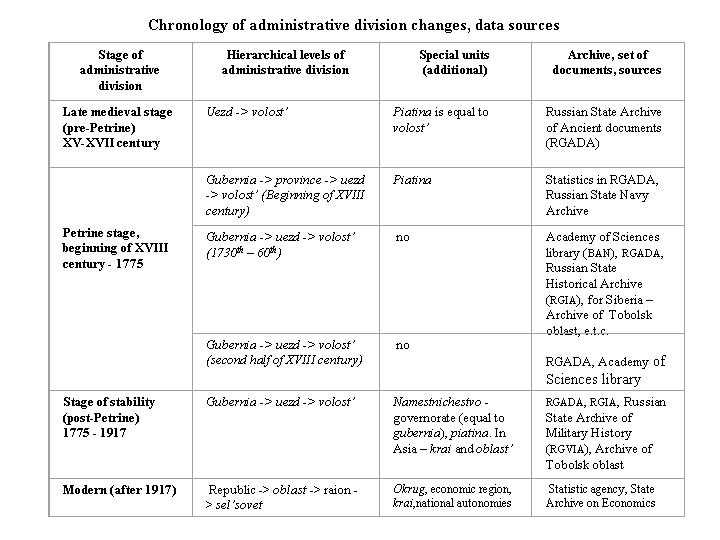
Late medieval stage (XV - XVII century): The country was divided into administrative units of the first level (uezd) that were divided into the second level units (volost'). At that time there were no fixed administrative boundaries neither on maps nor as landmarks. There was a lot of empty lands and very small population. Thus the most valuable subject of central power were people working on the land, not the land itself. The central authorities periodically compiled lists [4] of people and villages belonging to the same uezd and volost' Now they are used by historians for reconstruction of medieval administrative division [5].
Petrine stage (beginning of XVIII century - 1775): During almost the whole century the Petrine state was "building" spatial boundaries that were to represent the hierarchy of power, or, using modern Russian political slang "vertical of power". Mapping came hand in hand with the introduction of the new political approach, "cartography of power" (Harley, 1988).The Petrine surveyors did not simply chart boundaries, they set them in practice. At that time not only people became the subject of the state, but the whole geographical space and all things it included as forests and minerals (Karimov, 1999). The Petrine Generalnii Reglament [General Regulations -A.K.] in the chapter devoted to maps and plans stated the main purpose of mapping: "In order that each college [ministry - A. K.] should have an authentic inventory and information concerning the condition of the state and of the provinces belonging to it, it is necessary that there should be general and particular maps or charts in every college" (cited by D. Shaw, 1996). At that times of changes the still unclear primary conceptual models and expectations of the central administration had been laid upon the diversity of the real life and tested over people. The four-level division had been introduced: gubernia, province, uezd and volost'.
Stage of stability (1775 - 1917): In 1775 Catherine the Great among other reforms introduced the reform of administrative division and boundaries. This reform summarized the long period of changes. The surveyors of late XVIII - early XIX centuries were to adjust boundary lines in accordance with the lines of rivers and lakes, and to "round" the wedged borders. From one hand, it was the adaptation of the conceptual political models to the variety of nature and historic life, from the other - the adjustment and clarification of the very models of governance and regional administration. At that time the administrative boundaries really became to mean something practical. It was also an attempt to divide the country to the regions with equal population. 41 gubernia were introduced each consisting of uezd and volost'. This administrative division the same as the whole procedure of territorial governing in general remained untouched until 1917. During the next 130 years only a few new gubernia had been founded.
Modern stage (1917 - present): After the revolution of 1917 the administrative division changed often and rapidly according to the policy of central government. The national autonomies were introduced in 1920 - 1924 on all levels [6]. Except for short period the three-level division existed: oblast' (level of gubernia), raion (level of uezd) and sel'sovet - rural council (level of volost'). In 1927 - 1929 when the Stalinist team was establishing political control over the country, gubernia were aggregated into okrugs and four-level division was introduced. In the years of World War II the okrugs had been dismissed. Under Khrushev a frame of big economic regions [7] came to existence in 1957, but oblast returned back after his dismissal in 1964.
In general, administrative division, boundaries and "fences" remain to be the discourse of state, power, "discipline and punish", speaking in terms of Foukault.
Both of these Atlases cover all the country (with Siberia and North Kazakhstan) and show administrative division (gubernia and province level). Besides the Atlases there remained numerous maps and charts that served as the sources for them, as well as many maps of Petrine surveyors that were not used. The approximate number of map sources of Petrine surveyors that could be used in the project is about three hundred, but detailed research should reveal new archive sources. Besides there were compiled several regional Atlases, for example, Nerchinsk Atlas covering the territory of the South-East Siberia.
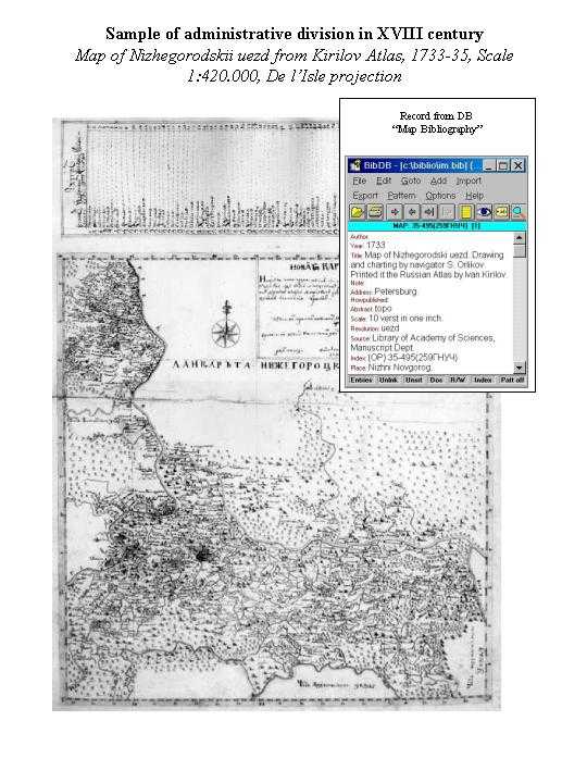
The sources for it had been manuscript maps of separate parts of the country (scales from 1:420000 to 1:840000). The main task of surveying at that time was the fast overview of the big regions of the country. Thus, the standard of map accuracy was intentionally reduced [8], but the main objects such as rivers, cities and villages, big forests and marshes could be located on the maps. A lot of objects had been mapped from remote basis. Sometimes the villages of the uezd are simply listed on the margins. But the surveyors paid special attention and accuracy in mapping of the administrative boundaries and the line along (Melnikova, 1954, Postnikov, 1989). Most of the maps had been done in the projection of De l'Isle or Mercator projection (Postnikov, 1989, p. 44). In general, boundaries on the Petrine maps could be re-drawn and digitized with the good quality.
The maps and corresponding field documents are stored in Moscow at Russian State Archive or Ancient Documents (RGADA), Russian State Archive for Military History (RGVIA) and in Petersburg at Russian State Historical Archive (RGIA) and Dept. of manuscripts of Library of Academy of Sciences (BAN). A valuable collection of contemporary maps of Russia collected by De l'Isle is stored at the French National Library [9].
Every map survey was followed by the gathering of detailed statistical data on population, waterways, forests, local tribes, trade etc. On the most general level they had been used by Kirilov who compiled the statistical overview of the country, first published at 1831 (Kirilov, 1977), but a lot of various detailed geographic data still remains unused. In 1837 and 1851 the broad and detailed statistical data was gathered by questionnaires sent from Academy. Besides this data there are statistical surveys that could be attached to the maps of administrative division: several censuses of peasant population, statistics of army recruits, forest statistics etc. Most of the documents of statistical surveys are stored at RGADA, RGVIA, Naval Archive, RGIA, Archive of Academy of Sciences in Petersburg.
Many valuable large-scale map surveys were carried out by land registry mapmakers and military surveyors. In the last quarter of the 18th century two edition of an atlas [10] were printed depicting the new framework of gubernia and uezd divisions. Notorious are the decorations of the maps being a kind of political message of Petersburg government on how it sees the regions of the Empire.
These atlases had been based on the countrywide land surveys [11] done by the Russian land registry. Up to the second decade of XIX century European Russia was covered by the detailed large-scale survey. It's narrow task was to compile a registry of land property, but the maps and plans done had been it full sense topographic, showing arable, meadow and forest lands, marshes, settlements, roads, administrative division of all levels etc. - the standard content of topographic maps. Land surveys could be a valuable source for the history of administrative division of late XVIII - early XIX century.
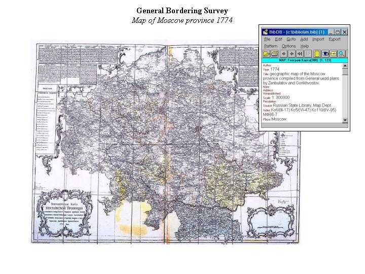
In total there were done hundreds of thousand of large-scale (1:8400) plans, several hundred of uezd atlases (1:33600 - 1:84000) and about a hundred of maps of gubernia (1:420000 - 1:840000). All the General bordering documents - maps, indexes, tabular statistics are manuscript.
General Bordering Survey was accompanied by the very detailed statistical surveys on the level of every village and land parcel. It included tabular data linked to the land parcel on the land use, population, usual crops and harvest, list of wild birds, animals inside the parcel, data on rivers, lakes and springs, often - about freshwater fish species. 90 percent of the pre-revolutionary statistical data was gathered and updated at that time. This period should be considered to be the most promising for such kind of project as we are going to develop.
The documents of the General Bordering Survey are stored in Moscow at RGADA, RGVIA, in Petersburg at RGIA, Dept. of Manuscripts of the Russian National Library and many Archives of the oblast'. Normally maps and atlases are kept separately from corresponding statistics, but at the same archive.
XIX century is not a new stage in full sense. The general framework of administrative division did not change since 1775. In Belorussia, Ukraine, Crimea and at the Central Asian frontier administrative division of these areas became more subdivided. This process was fastened by the abolition of serfdom in 1864 when a lot of peasants settled the south Russian steppe. But at that time initiative on surveying and mapmaking descends from Land Registry to the General Staff. Military topographers charted lots of accurate and detailed maps and plans that deserve special paragraph [12].
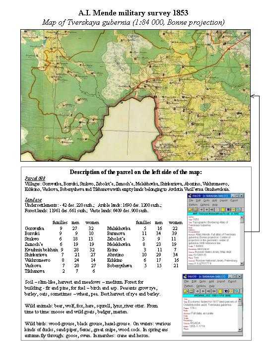
The main sources for study of administrative division of that period are the military surveys carried out by the Russian General Staff. Military topographers were anxious to update the maps of the previous century and to create more accurate and detailed maps. Since 1830 The General Staff maps show relief. There were done numerous surveys, among them - A Hundred-Listed Map of the Russian Empire, 1801 (1:840000), F.F. Shubert "Special map of European Russia", 1821-1839 (1:840000), topographic drawings of Siberia, 1820th - 1830th, Survey of the Western Russia, 1845-1863, 1:126000, A.I. Mende survey of internal Russian gubernia, 1847-1866, scales from 1:42000 to 1:816000, I.A. Strelbitsky Special Map, 1865 - 1917 [13] and many others (Postnikov, 1989). European Russia was the polygon of most of the surveys, but a lot of them took place at Central Asia, Pamir, Siberia, Kazakhstan. Obviously, administrative borders are shown on most of these maps.
The military maps are stored mainly in Moscow at RGVIA and RGADA. The total number of maps done by military topographers could hardly be evaluated, but no doubt it is above several hundred thousand. Most of them despite of the age had been classified before 1992. The classified maps were unavailable for researches except for very valuable reasons. These maps were stored in a special remote archive in Siberia. In 1990th these maps were returned to RGVIA and are now available.
Similar to the land surveys of XVIII century, military mapping was followed by statistical surveys. Military topographers gathered detailed information on population, houses, crops, harvest, land use, horses. A.I. Mende survey of internal gubernia is the most notable. The program was done so that the maps and tabular data should be comparable with the data of the General Bordering survey. Mende surveyors gathered statistics on population, land use, crops, harvest, wild birds and animals, freshwater fish etc.
Besides military statistics huge volumes of tabular data had been gathered, updated and periodically published by local administration [14] of gubernia in 1864 - 1918. At those parts of the country where zemstvo was not established, statistical surveys were carried out and updated by the statistical committee under the governor. These surveys include information on many aspects from population and land use to education, health and criminal statistics. All this data is linked to the corresponding level of administrative division - gubernia, uezd, volost' and separate villages. Most of this information was published and available in main libraries, unpublished is stored in RGIA and oblast archives.. Zemstvo statistics will be a significant addition to the proposed information system.
All the administrative changes of the Soviet period are refereed to the corresponding Acts of the supreme powers. There are guide books on administrative division for each year and detailed special maps showing administrative reforms of the high and medium level. This data could be directly used in GIS, redrawn, digitized and processed.
The great amount of official statistics gathered by the Central Statistical Agency and statistical surveys of oblast could be overlaid on spatial data. Most reliable is the information before 1930. Selected data of the federal, oblast and raion levels since 1970th is available in electronic form. Current official statistics could be obtained in electronic form from about 1990th.
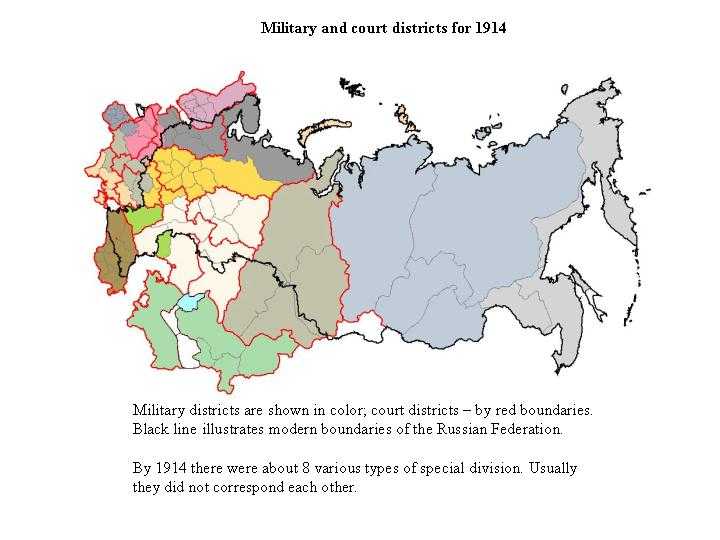
There were several types of special division besides administrative gubernia and uezd. Since 1864 the country was divided into court districts. A group of gubernia was a subject of one district court. There was diocese division set by the Orthodox Church. There existed also military districts subordinated to Governor general, and some other types. Special court, military and other units usually included several gubernia or even did not correspond to the framework of administrative division. This was a form of "division of powers" in geographical space.
We plan to design our historical GIS in order to achieve the following results: (1) reconstruct administrative division at any hierarchical level for the requested time period; (2) reconstruct temporal dynamic of administrative borders for local units; (3) check the administrative affiliation of an area or village, (4) view the temporal dynamics of name changes for settlement or local unit; (5) in perspective allow researchers to input new information, extract data and use them for their own purposes with the most common GIS software (and through Web interface).
We are going to proceed through the following chronologically independent steps:
Taking as basis administrative division of Russia in 1914 we consider it to be the most accurate and completed for the whole territory of Russia. At the same time this date corresponds to the last stable year before post-revolutionary fundamental changes.
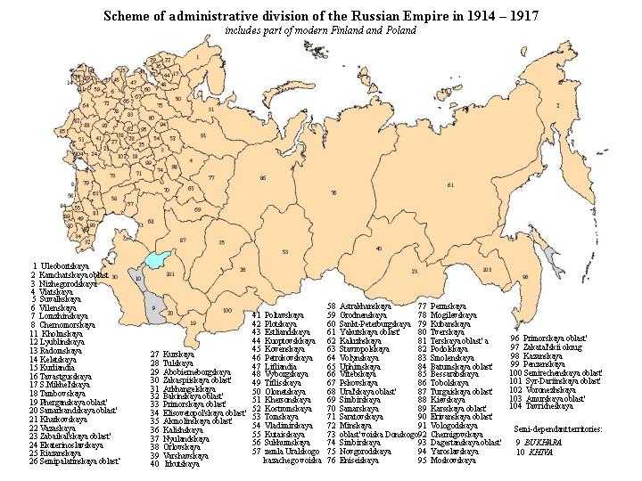
We have to compose this layer from Strelbitskii map, topographic surveys in Siberia and military-topographic surveys in Central Asia for the beginning of XX century. All data will be digitized into ArcInfo 8 down to the volost level. As a result we will have about 6-10 thousand polygons. Geometry for earlier time periods down to 1775 will be input and kept in form of changes to the basic layer.
The main types of problems we have to deal with relate to the data handling and data interpretation.
The first one deals with necessity to use different methods for data input in order to achieve compatibility of various sources. Distinction should be made between data produced in different epochs.
The maps of XIX century could be digitized directly.They have scales from 1:84 000 to 1:420 000 that allow to generalize them to the scale 1:1 000 000 keeping accuracy at acceptable level. The last scale is chosen as a basic for the whole product in order to comply our materials with already prepared layers in the Institute of Geography (group of N.N. Kamedchikov) and agree our efforts with the international community.
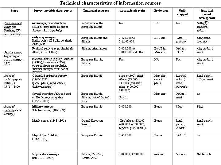
Speaking about very big and diverse materials in general, we like to emphasize that the accuracy, technology and instruments of the military surveys is comparable with the modern maps. There was a special program of astrogeodetic measurements to back up the topographic surveys, and most of the geodetic data had been published. Even the Bonne projection the XIX century surveyors used is supported by the Workstation version of Arc/Info GIS! All the instructions and data necessary for digitizing and recalculation is easily available from the printed survey instructions. There exist even the evaluations of the accuracy and standard errors of many of such astrogeodetic measurements and map surveys [15].
Digitization of maps from the end of XVIII century is possible to a great extent. Large scale parcel plans of the General Bordering Survey are done without projection. But uezd atlases, gubernia plans and overview small scale maps for the whole country are done in Mercator projection. The accuracy of these maps is much higher than the Petrine surveys. More objects were mapped by triangulation and measurements, among them - roads, administrative borders, rivers and borders of land property. The triangulation network had been much more tight and the number of astrogeodetic points was higher. The geometric characteristics of this land survey and the ways to overlay them onto the modern maps had been studied by Gedymin (1960) and his conclusions make us secure about the possibility of using these maps with the modern GIS.
Maps produced before 1775 could not be adequately input in electronic form. Although they have detailed scales (1:420 000 - 1: 840 000) and projections with known parameters (Mercator or De l'Isle [16]), the technology of surveys was not accurate and standard error in comparison to modern maps was great. For some territories survey was exploratory. It is reasonable to redraw boundaries from that maps on the modern topographic basis and then digitize.
The problems of data interpretation appeared because surveys of the large territories lasted for many years (the General Bordering Survey started in Moscow gubernia in 1766 and ended in 1822 in the South of the European part). We can talk about the synchronic "slice" for single gubernia but not for the whole European Russia. It is important that mapping and geographic exploration followed the expansion of the Russian frontier since XVI up to the end of XIX century. Some of the annexed regions of Central Asia were mapped in a very large scale to back up military actions or delimitation disputes (Postnikov, 2001) or their potential value for future colonization as it was at the Far East and Siberia. Some - with small resources and scarce population - were mapped in small scale. In general there is an noticeable predominance of cartographic materials for the European part in comparison to Siberia and Asia and there could be several scale gaps, when only small scale materials is available.

For early surveys and for the territories of Siberia the essence of the bordering was to distinguish the administrative affiliation of villages and cities. It means that the accuracy of delineation does not require precise digitization of boundary line from the maps. For that kind of maps we should verify boundaries by the database Settlements, which is now in started. Additionally we plan to use a hydrographic layer, which is very useful in locating boundaries and settlements. It is being compiled by the local dealer of ESRI, Inc.
Additionally we are going to use indirect information to fill gaps. It is the Full Edition of Laws of the Russian Empire, fixing establishment and dismissal of gubernii; Official List of settlements fixing placenames, settlement and their affiliation. Data will be extracted also from annual reports of Governor, being kept in oblast archive.
The way to solve the problem of data interpretation could be the flexible database design allowing to keep data intervals (fields "from"-"to"), versions of boundaries or multiple entries for the same object (derived from different sources). It is very close to the approach practiced by the developers of China historical GIS (L.W. Crissman, 2000).
The concept of the Database supposes a set of relational tables, being built in Oracle 7. This will allow to process complex queries along time and spatial axes. There is only a draft of the database, which by our opinion reflects specificity of data we posses and are going to work with. The main principle is that we distinguish several types of objects within our system:
The smallest spatial entity will be artificial polygon with unique historical sequence of administrative affiliation. In each moment of time it is a part of some existing administrative unit. The point objects represent settlements.
The virtual objects correspond to administrative units until they have the same name. We presume that the change of the name means that the new administrative object appeared. This reflect the real situation, when then the renaming means usually radical administrative reorganization.
Most of the statistics collected during the XVIII-XIX centuries relates to the single settlement, and only generalized statistics to uezd and volost'. Thus attributes will be incorporated into the database "Settlements" and include the following draft list of parameters: population number, number of households, some agricultural statistics.
We can suppose that the structure of our database after we start to fill it with information may gradually change. In any case it should transparently reflect all types of administrative changes having occurred during the discussed period.
Analysis of already collected material shows several types of changes in administrative division, occurred in the observed period:
Changes of the boundary geometry are of two subtypes:
In the periods of administrative reforms up to 90% of administrative units had been changed per decade. In quiet times local adjustments were no more than 1-5% per each year. It is hardly imaginable that any boundary changed two or more times a year. Agricultural statistics related to administrative unit was gathered once a year in accordance with the agricultural cycle.
Changes of the placenames of administrative units and settlements usually meant serious reorganization of a unit, but were less serious for settlements. Before 1917 many settlements had multiple names: folk and official ones. Sometimes folk names were unquotable and according to a special surveyors' instruction of 1770th few letters of such names were to be changed to make them sound better. Both local and official names were fixed in uezd Bordering Atlas and land use statistical records. After 1917 we have only official name and very often it is different to the pre-revolutionary. The changes in names were reasoned mainly politically.
Changes of administrative status were rare and meant transformations of the hierarchy status of administrative unit. This may occur due to increase (decrease) of population, political factors. For example, after the forced resettlement of highland Pamir Tajiks to the plains the status of highland districts reduced.
In comparison to the China's administrative system there were no coding system up to modern days.
By the moment we started to build database of settlements for the beginning of the XX century which will be additional helping material for verification of boundaries.Now we are at pre-project phase and by today we have already:
The work on the GIS of the administrative boundaries is now in starting phase. Timetable, volume and content of the system will depend on the small indirect funding that we already receive from our institutions and potential grants we are going to apply for. We would appreciated any opportunities of collaborative projects, open to any recommendation and ready to make our data compliant with the data of our potential partners.
[1] Historical data is used not only by historians. Researchers working with old collections of minerals, insects, plants and even folk songs often need to locate places of findings on the map of modern administrative division. Environmental decision makers use historical maps to locate old areals of rare animals or to reveal untouched old growth forests (see http://www.forest.ru).
[2] The project was done at the Institute of the History of USSR. It included academician Ia. E. Vodarskii, L.G. Beskrovnyi, V.M. Kabuzan, A.V. Postnikov.
[3] North half of the map was based on the map of J. Got'e map of Russian administrative division to the North of Oka river (Got'e, 1906).
[4]Books of Survey - pistsovye knigi.
[5] There were no maps of XVII century that could be used to study administrative division.
[6] Federal level - national Soviet Socialist Republics - members of the Union of Soviet Socialist Republics - USSR, republican level - autonomous national republics, included into the National soviet Socialist Republic, national oblast', okrug and raion - lower level division.
[7] Approach worked out by Soviet economic geographers and used at the State Planning Committee (GOSPLAN) (Baransky, 1926).
[8] It was a matter of dispute between Russian statesmen and geographic practitioners of high rank, as Kirilov, Tatishev and Miller interested in fast mapping of the country and academician J.-N. De l'Isle, first director of the St.Petersburg observatory and author of the first program of surveying of Russian territory. The activities of academician De l'Isle in Russia still receive controversial response. He was an author of special projection for Russia used up to 1870ies. He did a lot to develop astronomy and coordinates measurement in Russia. But his program of surveying based on the numerous accurate astronomic observations, required too much time and staff and thus remained on paper.
[9] De l'Isle belonged to a family of historian Claude de l'Isle. His brother Guillaume, a student of astronomer and mapmaker J.-D. Cassini, became famous for his maps and globe published in 1702. J.-N. De l'Isle was strongly influenced by the ideas on Earth measurement, mapping of the world, collecting of new geographical data and astronomic observations. He sent copies of the Russian charts and maps to Paris having in mind to prepare a revision of his brother's map. This costed him his high position in Academy and in 1747 he was to leave Russia (Urness, 1990). The contribution of De l'Isle to the Russian astronomy and cartography is still understated and understudied.
[10] Russian Atlas consisting of forty four maps and dividing the Empire in forty two gubernia. Petersburg, 1792. Edition II in 1800.
[11]Generalnoe Mezhevanie or General Bordering Survey.
[12] Professor A.V. Postnikov did an exhaustive research on the history of the military surveys of XIX century (Postnikov, 1989).
[13] Was used by the Staff of the Red Army till 1939.
[14] In 1864 it was established elected self-government in most of the Russian gubernia - zemstvo
[15] Professor A.V. Postnikov proved military surveys of XIX - beginning of XX centuries to satisfy the modern requirements to the map accuracy. Being a member of the Foreign Ministry Commission for checking of the Soviet - Chinese boundary in 1980th he worked out special methods of using old maps and field observations for that purpose.
[16] The last designed specially for maps of Russia by academician De l'Isle.
© Irina Merzliakova and Alexei Karimov, 2001