Göran Kristiansson (The Regional Archives in Lund)
In a governmental investigation "Öppenhet och minne", presented 1988, it was stated that building a National Archival Database (NAD) was of great importance. The idea was that it should make more people aware of were to find archival information. The database should give information about archives in Sweden, how they could be reached and how to use them.
The task of building the database began 1990 as a development project in the Swedish National Archives. The first prototype on CD-ROM was produced 1992 and the first edition was made in 1993. The information in the database can for example be retrieved by name of the archive, name of creator, personal name, category, subject and geographical name. For more information see also http://www.ra.se/nad/pro/naddemo3.htm.
A key factor for finding the correct archival information is the knowledge of administrative boarder changes in the country. Therefor it was of vital importance to build a national topographical database as a support for the NAD.
The first step was to find the smallest building block for the database, that is the most stable administrative unit over time. The parish was found to be the best choice, because it has been the most stable unit from the 1700-century to present time. The 1990 parish boarders was used as a starting point. Digital maps were bought from the National Land Survey and maps showing the borders of historical parish were scanned. Information about historical parishes, changes in parish boarders and parishes relations to other administrative units was collected from the National archive, the regional archives and different investigations made by historians. The information was keyed in to a relational database were the parish information was related to about ten different administrative units. For example:
|
Parish |
code |
Province |
time |
|
Bromma |
018027 |
Uppsala |
1654-1714 |
|
|
|
Stockholm |
1715-1915 |
|
|
|
|
|
|
|
|
County |
|
|
|
|
Sollentuna |
- 1906 |
In Sweden the parishes have a special code given to them by the Central Bureau of Statistics for planning and statistical purpose. This code was used as a unique key and three digits were added for the historical development. For example the parish of Västra Skrävlinge was incorporated in Malmö 1911 and Limhamn 1915:
|
Parish /town |
code |
|
Malmö |
128000 000 |
|
V Skrävlinge |
128000 001 |
|
Limhamn |
128000 002 |
Maps with administrative units such as counties, provinces, municipality’s etc, were built by these parishes as building blocks.
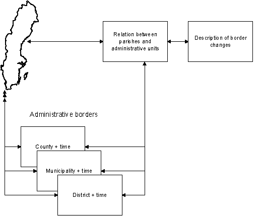
Graphically, the information structure of the database can be shown as follows:
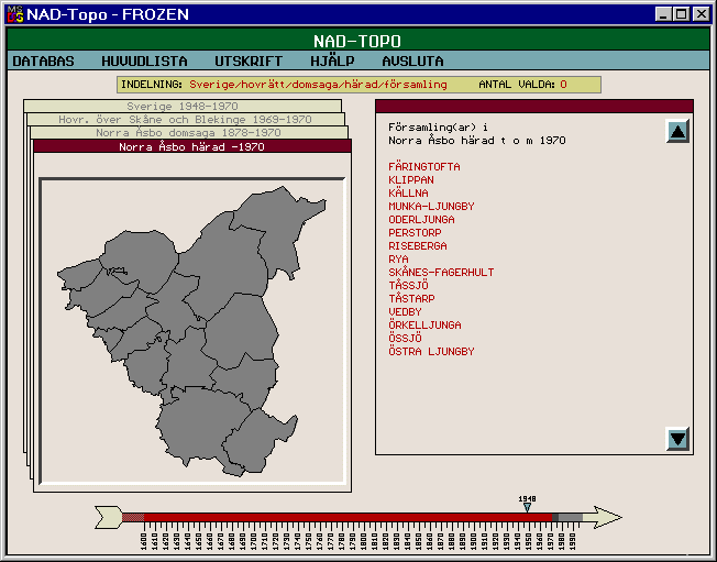
This structure was implemented in a computer program built in the object oriented programing language C++. The user interface is divided in to parts, one map and one text area. In the lower part of the screen there is a time scale were you can choose the appropriate year. If you point and click with the mouse on the map it will change to the next level. The map will show all the administrative units that compose the higher unit. The text will describe the changes. At the parish level there is a text describing all minor changes to the parish border.This structure was implemented in a computer program built in the object oriented programing language C++. The user interface is divided in to parts, one map and one text area. In the lower part of the screen there is a time scale were you can choose the appropriate year. If you point and click with the mouse on the map it will change to the next level. The map will show all the administrative units that compose the higher unit. The text will describe the changes. At the parish level there is a text describing all minor changes to the parish border.
© Göran Kristiansson (Lund, May 2000)