Q. Name of project
Great Britain Historical GIS Project (NB our long-term goals include working on Ireland in collaboration with the Database of Irish Historical Statistics team in Belfast. To date, our statistical database contains much data for Scotland but our boundary mapping work is limited to England and Wales.)
Q. Principal researcher(s)
Chris Bennett (left project 18 months ago, but responsible for archival research)
Victoria Gilham
Ian Gregory
Humphrey Southall
Q. Who can/should be contacted now, and how?
|
Name: |
Dr. Humphrey Southall (Director) |
|
Postal Address: |
Department of Geography, University of Portsmouth, Buckingham Building, Lion Terrace, Portsmouth PO1 3HE |
|
E-mail Address: |
Humphrey.Southall@port.ac.uk |
|
Web site: |
http://www.geog.port.ac.uk/gbhgis (There is a lot there!) |
Q. When did research begin?
Construction of our statistical database began in 1989, but our work on boundary mapping began in 1994.
Q. Is the project still in existence? If it has ended, when did it end? If it still exists, when is it expected to end?
Yes. We expect boundary mapping of civil administrative units for England and Wales to terminate during 2000, but work on Scotland is planned for 2001. There seems to be an indefinite scope for extending the system. We have external funding for analytic work on the GIS extending through 2002.
Q. What institution(s) was the project based in?
The project was initially based at Queen Mary and Westfield College, University of London, but moved to the University of Portsmouth in January 2000. Since April 1998, we have been funding a second team in Belfast to take responsibility for statistical data entry.
Q. How many people were/are employed, and for how long? Were these people recruited specially for the project, or were they already employed by the institution(s)?
The project currently employs three full-time staff in Portsmouth, all funded by the Economic and Social Research Council, plus two full-time staff and seven Information Technology trainees in Belfast, mainly funded by the Wellcome Trust. At its peak during 1997 and 1998, the project in London employed four staff working directly on the historical GIS, with very varied funding, plus a fifth researching methodologies for authoring electronic historical atlases and an unpaid director (he now has his own Research Council funding, and can do things like organise European workshops).
Q. How much did the project cost?
Total funding obtained to date is c. £862,000 (c. €1,437,000), including substantial funding for the Belfast team. The direct cost of GIS construction has been c. £500,000 (c. €833,000).
Q. Who paid for the project?
The project has been funded, to date, by 25 separate awards from 12 different funding sources: the Aurelius Trust, the British Academy, English Heritage, the Economic and Social Research Council, the Joint Information Systems Committee, the Leverhulme Trust, the Marc Fitch Fund, the Nuffield Foundation, the Pilgrim Trust, the Population Investigation Committee, the Roehampton Institute and the Welcome Trust. However, the Economic and Social Research Council has been much the largest source of funds.
Q. If the project is still underway, has all necessary funding to complete the project been raised?
We now have sufficient funding to complete the historical GIS for late 19th and 20th century England and Wales, and to carry out an extensive range of linked research. However, there are significant areas where further funding would be very desirable, notably gazetteer construction.
Q. How easy has it been to raise the money?
For a long time, very difficult indeed, as is shown by the sheer number of grants we had to obtain; and the number of grants created a great deal of administrative work. At one critical point, key staff were kept in post only by using money we had earned by running short courses in GIS for other historians. Over the last two years, we have obtained some much larger grants, and arguably one of our main achievements is convincing funding organisations that this is a field needing and justifying large scale funding.
Q. Other than raising the money, what are the biggest problems your project has faced?
Q. Have there been any pleasant surprises in the course of the project?
When we started, this was a strange and rather isolated project; now there is ever-growing interest from a very wide range of historical researchers. In particular, providing a base-mapping facility has proved to be a excellent way to obtain collaborative access to other researchers' data.
Q. How likely is it that further funding might be raised within your country for a collaborative European project?
We probably have enough 'project' funding already to complete our core system. Sustaining and spreading our expertise is more of a problem, and a European project might help justify this.
Q. What geographical area is covered by the project? What is the MODERN legal status of this area? (i.e. is it a nation state, a province of a nation state, etc). If the area currently lacks a legal definition, when was it defined and by whom?
Our existing work is specifically limited to England and Wales, two nations within the state of the United Kingdom. We intend to extend the system to include Scotland.
Q. Does the project aim to: (a) Reconstruct boundaries at a single date; (b) Reconstruct boundaries at a series of dates; (c) Construct a continuous record of changing boundaries over a period?
From the start of the GIS project in 1994, we have always aimed to create a continuous record of changing boundaries.
Q. What is the earliest date covered by the project?
Our parish-boundary mapping covers the period since 1876. Systematic boundary-change information is not available for earlier dates, but we believe our work provides a useful basis for mapping data from much earlier periods; we have experimented with data from as far back as the Domesday Book of 1086.
Q. What is the latest date covered by the project?
Our work ceases with the major revision of the system of local government within Great Britain in 1974. This is partly because digital boundary mapping is available for subsequent census years (1981 and 1991), but also because of copyright considerations.
Q. What systems of units are included?
The system covers:
Civil Parishes were the basic building blocks from which many other administrative hierarchies were constructed. We hope, in particular, to add the boundaries of Parliamentary Constituencies, 1832-1974.
Q. What is the project's final product?
The central product of the boundary mapping project will be a set of Digital Boundary Data (DBDs) deposited with the UKBORDERS service based at Edinburgh University. This will then be made freely available by them to the UK higher education community, their on-line system enabling registered users to download boundary data for a selected area, type of unit and date, in a variety of file formats. Our statistical data is similarly being made available on-line through the Essex Data Archive. We are hoping to publish a paper atlas charting long-run change in Britain, as recorded by the census since 1801, as well as a range of research-based publications. There may well be scope for a paper atlas of historic boundaries.
Q. What other publications has your project produced? In particular, please give details of any publications on methodology, and any publications in other languages?
I.N. Gregory and H.R. Southall, ‘Putting the Past in Its Place: the Great Britain Historical GIS?tm), in Carver, S (ed.) Innovations in GIS 5 (Taylor & Francis, 1998), pp.210-21.
H.R. Southall and B.M. White, ‘Visualising Past Geographies: the use of animated cartograms to represent long-run demographic change in Britain?tm), pp. 95-102 in Mumford, A (ed.) Graphics, Visualisation and the Social Sciences (Loughborough: Advisory Group on Computer Graphics, Technical Report Series no.33, 1997).
For a description of the database before the boundary GIS was added, see Gilbert, D.M., and Southall, H.R., ‘Indicators of regional economic disparity: the geography of economic distress in Britain before 1914?tm), in C. Harvey and J. Press (eds.) Database Systems and Historical Research (Basingstoke, 1996), pp. 140-6.
Q. What base map is/was used to record the information? When was it created, and by whom? Is it published or in an archive?
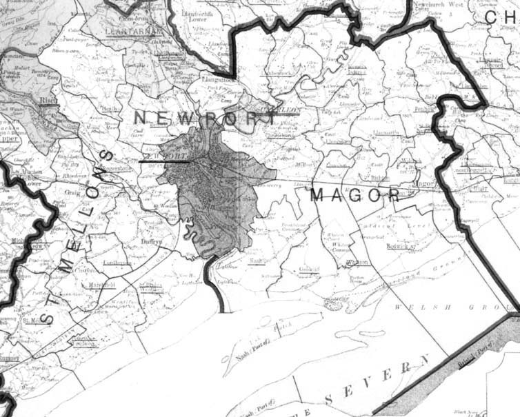
Our master base maps are a series of 'County Administrative Diagrams', published by the Ordnance Survey (the national mapping agency) between 1906 and 1910. We use this second edition rather than the first edition, published in 1900, because it uses a single projection for the whole country. Here is a sample from one of these maps:
Q. What scale was this base map on?
2 miles to the inch (1:126,720).
Q. If the base map was not already in digital form and your project created a digital version, how was this done?
We manually digitised the maps county by county. We assembled a single national coverage from the county sheets by locating features, such as churches and railway junctions, which appeared on both our master maps and on more recent maps using the National Grid (a standardised co-ordinate system), and which were near the edges of counties and therefore appeared on the maps for more than one county. By using these features as our 'tic points' it was possible to both join county sheets and transform the whole system to National Grid co-ordinates.
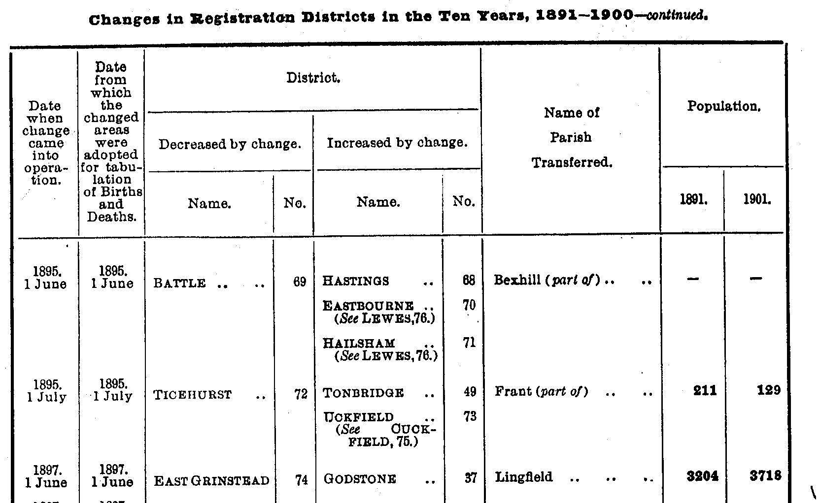
Q. If your project constructed a record of boundary CHANGES, what sources of information were used? How was this information gathered?
Systematic lists of boundary changes for municipalities appeared in the Annual Reports of the Local Government Board; for Registration Districts in the Annual Reports and Decennial Supplements of the Registrar General; and for parishes in the census reports. We constructed conventional textual databases from all these sources. Here is an example of a list of Registration District changes:
Q. What other maps besides the base map were used? When were they created, and by whom? What scale were they on? What boundaries did they show? How reliable are they?
We used a number of other series:
We believe these maps to be generally highly accurate; the main problem is that there are two few maps available for the early part of our period.
Q. Did your project make any use of DESCRIPTIONS of boundaries? Who created these? Where are they preserved? What problems did you have converting this information into lines on maps?
No. The Ordnance Survey boundary change files, held in the Public Record Office in London, do include such information but cover only a short period and a limited area. They are very confused, and would be impossible to interpret reliably without local knowledge. We concluded that they would provide only limited enhancement of what we could create from more easily interpreted sources, and at vast cost.
Q. Please give full publication details (author(s), title, place of publication, date of publication).
We have no current plans to publish a conventional atlas of administrative boundaries; our planned historical atlas will contain relatively small-scale maps, showing the whole of Britain on each page.
Q. What software was used?
Our system is based on the well-known commercial GIS package, Arc/Info. However, we have substantially extended its functionality so as to include a continuous time dimension via very extensive custom software written in Arc Macro Language (AML). In our system, both boundary lines (arcs) and administrative units (identified by their label points) are systematically date-stamped via their attribute tables. Our software uses the dates in the attribute tables to select those units and boundaries which existed at the date specified by the user, and then constructs a conventional polygon coverage for that date.
Q. If your GIS was specially written for you, or heavily tailored for your project, who was responsible for programming? How can they be contacted?
The system was developed by Ian Gregory (Ian.Gregory@port.ac.uk).
Q. What were your reasons for your choice of software? If you started again now, would you use the same software?
We used Arc/Info because:
Q. Describe the data files making up the final system: Are they a standard GIS file format? If not, where can detailed documentation be found?
The data files are a series of conventional Arc/Info coverages, but with extended attribute tables as described above. We are supplying the system to the Essex Data Archive as a set of Arc/Info UNGENERATE files, an ASCII format, with documentation designed to permit their use independently from Arc/Info. However, this is to meet the needs of very long-term archiving, and for most practical purposes the on-line system operated by UKBORDERS will be more useful, providing base maps for selected single dates in a range of GIS file formats. NB our system is no so much an electronic base map as a base map generator.
Q. What map projection is used?
The original base maps we digitised used the Modified Cassini projection, although Arc/Info includes extensive facilities for transforming projections and can easily output maps in the Transverse Mercator projection now used by the Ordnance Survey.
Q. Assess the overall accuracy of your digital mapping.
We believe that our system locates features accurate to c, 100 m, which is very accurate for demographic analysis but obviously less acceptable to archaeologists! The limitations on accuracy result from the scale of our base maps. Note that the temporal accuracy of our system is very high, boundary changes being located to the precise day.
Q. From your existing experience, what methodological recommendations do you have for a larger collaborative project?
Q. If the end-product is neither a traditional publication or a GIS, please describe it?
Most of our funding has been for digital resource creation, essentially creating the GIS as a tool which can be used by other researchers, notably historical demographers. However, a distinct sub-project has investigated methods for creating a web-based historical atlas. For an extended demonstration, look here:
Q. Whatever the resource your project has actually created, and in the light of your experience with the project, what form of output SHOULD a new project have?
There is arguably a need for both a cartographic framework, like our national historical GIS, and for historical atlases which make use of such a resource. It would be best to build the framework before worrying about creating atlases, but this boundary mapping may not be exciting enough by itself to obtain the necessary funding.
Q. What place-names are built-in to your mapping? Is each point/area (node/polygon) labelled with a single name, or is there some system for linking to different versions of names?
At present, each administrative area is given a single name within the GIS (although the time-variant nature of the system allows for name changes, as distinct from multiple concurrent names). However, the GIS is linked to our statistical database via gazetteer tables which allow for many variant forms of names. Construction of gazetteers for counties and districts was a relatively modest task, but parish-level gazetteers, covering over 15,000 units and many more place-name variants, has proved a much larger task.
Q. Does the history/linguistic geography of your area raise special problems with naming places?
For most of England, there are relatively few problems. However, in Wales and near its borders there are problems both with places having English and Welsh names, and with large recent changes in Welsh names to achieve a more authentically Welsh spelling.
Q. Have you any plans to make the place-name information gathered by your project available in any other form?
Yes. We have now obtained specific funding for place-name gazetteers, with the goal of creating both better tools for linking our statistical information to the GIS and also tools for other uses. In particular, we believe our gazetteers can be used to provide an on-line finding aid and also a resource discovery tool: by providing various databases with knowledge about relationships between areas, they can for example enable users looking for information about a particular county with information labelled by towns and villages within that county. The History Data Service at Essex and the UKBORDERS service have joint funding to research the potential for on-line gazetteers and finding aids, and we hope to work with them on content creation.
Q. What sources have you used to research place- and area-names for use in your system?
Our main source of information to date has been the very extensive geographical information contained in the various census and vital registration reports. However, our new funding for gazetteer construction includes creating a computerised equivalent to F. Youngs' Local Administrative Units of England (Royal Historical Society, London, 1979 & 1991), the established authority for England; we have permission from the Royal Historical Society to computerise the book where appropriate.
Q. Are there any quite separate projects concerned with the history of place names or of administrative hierarchies in your area? If so, please give details? Are they using computers? Are they aiming to make their results available on-line?
The English Place-Name Society has been researching place-names for many years, and publishing a series of county volumes. However, much of their work concerns the meaning of place-names, and as far as we know they have no interest in computerising. The Victoria County Histories are undertaking somewhat similar work to ourselves, but proceeding much more slowly. To date they have not computerised but this may be about to change, and we are interested in the scope for collaboration.
Q. Was the GIS/digital resource constructed for use by its creators ONLY, or was it intended for wider use?
Although the very first funding we obtained was to add a mapping ability onto our own statistical database, within our first year we obtained funding from another project to enhance our system to provide them with a better base map. More recently, our large scale funding has been mainly to create a resource for use by the UK Higher Education community as a whole.
Q. Are you willing to make it available for use by others?
Yes.
Q. Are you willing to make it available for free, or for distribution costs only? If not, what plans have you for commercial distribution?
In principle, our system will be freely available once complete (but see below).
Q. Is the resource available NOW? If so, how and from where?
Our mark I system, covering pre-1911 Registration Districts and Poor Law Unions, is available from UKBORDERS now. Our mapping of pre-1911 parishes should be available in the next six months:
Q. Are there any limitations on access?
The main limitation is that we ourselves are not funded to act as a point of dissemination (and are unwilling to do it in our spare time!). The UKBORDERS service in Edinburgh is funded to run an on-line boundary dissemination service -- but only to universities in the United Kingdom. This poses problems for both non-UK academics and non-academic users in Britain.
Q. What file format or file formats is the resource available in?
UKBORDERS can create digital boundary files from our data in a wide range of formats.
Q. If the resource is available from the researcher/project that created it, what plans are there for distribution after the project ends/the researcher retires?
It will be available from UKBORDERS so long as their service is funded. The ASCII version deposited with the Essex Data Archive will be preserved indefinitely.
Q. What plans are there for updating the data files for use with more recent versions of software?
This is the responsibility of UKBORDERS.
Q. What plans are there for updating the data files to include the results of more recent historical research?
We have some funding to enhance the GIS running through to late 2002, but lack specific funding to incorporate additional boundary research.
Q. Do you own all intellectual property rights in the resource created by your project? If not, what other rights exist, and who do they belong to? What limitations have they imposed?
We have gone to considerable effort to ensure that our system is based entirely on out-of-copyright sources, with the unavoidable exception of new boundaries created post-1950. The only other rights that exist in our system are that our parish boundaries for central London, and especially the City of London, are based on earlier research by Craig Spence, then at the Centre for Metropolitan History and now at Goldsmith's College, both within the University of London (he can be contacted as c.spence@gold.ac.uk).
Q. How have Intellectual Property Rights issues limited your project?
The main problem has been the policies of the Ordnance Survey, the UK national mapping agency. Their commercial orientation is such that we have had to assume that any extensive use of their copyright material would make dissemination of our system hard if not impossible. The most obvious consequence is the limitations on accuracy of our system.
© Humphrey Southall (Portsmouth, May 2000)